← All interactive maps

Wildfire · Grand County, Colorado · October 2020

Eight hours, 87,000 acres

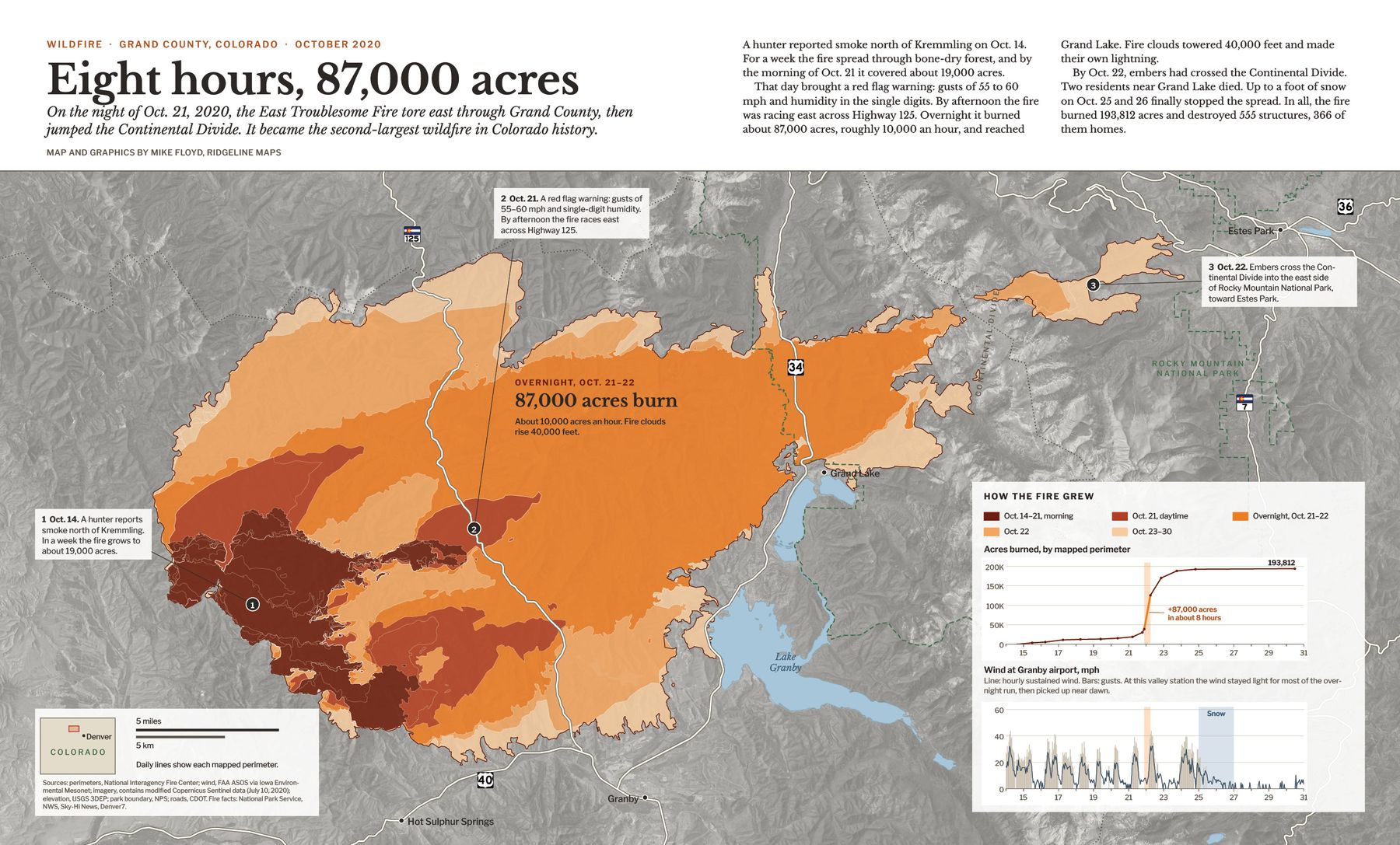
On the night of Oct. 21, 2020, the East Troublesome Fire tore east through Grand County, then jumped the Continental Divide. It became the second-largest wildfire in Colorado history.

A hunter reported smoke north of Kremmling on Oct. 14. For a week the fire spread through bone-dry forest, and by the morning of Oct. 21 it covered about 19,000 acres.

That day brought a red flag warning. Overnight the fire burned about 87,000 acres and reached Grand Lake. By Oct. 22, embers had crossed the Divide. Snow on Oct. 25 and 26 finally stopped it.
Map of the East Troublesome Fire perimeters between Granby, Grand Lake and Estes Park
Loading the perimeters…

  • Oct. 15–21, morning
  • Oct. 21, daytime
  • Overnight, Oct. 21–22
  • Oct. 22
  • Oct. 23–30

Hover or tap the burn to see when each part caught fire. Scroll or pinch to zoom, drag to move.

Acres burned, by mapped perimeter

The animation

The same perimeters as a 30-second animated map, with wind readings from two weather stations before each mapped perimeter.

The magazine spread

A two-page print layout of the overnight run, with an acreage chart and the wind at Granby airport through the whole fire.

Two-page magazine spread titled Eight hours, 87,000 acres, with a large map of the fire colored by day, a chart of acres burned and a chart of wind at Granby airport

Sources

Fire perimeters: National Interagency Fire Center, Operational Data Archive 2020. Acres for each perimeter are measured from the mapped shapes and differ from official figures by less than 0.1%; the official final total is 193,812 acres. Times are Mountain Daylight Time, when each perimeter was mapped.

Imagery: contains modified Copernicus Sentinel data (July 10, 2020). Elevation: USGS 3D Elevation Program. Lakes: USGS National Hydrography Dataset via Esri. Park boundary: National Park Service. Wind (animation and spread): FAA ASOS and CDOT via Iowa Environmental Mesonet. Fire facts: National Park Service, National Weather Service via Sky-Hi News, Denver7.

Need a map like this?

Ridgeline Maps makes custom maps of fires, avalanches, trails and the places you care about, for print, web and video.